Average Center of Tornadoes by Year in USA

geometrical tornado center map usa

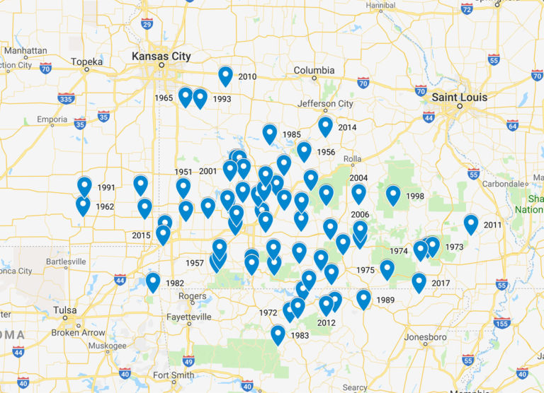
Yesterday, I calculated the “Tornado Capital of USA” to be Diggins, MO, based on the average latitude and longitude of all tornadoes between 1950 to 2017. This got some attention on Twitter and one comment I got was if I could make the same calculation but grouped by year instead so here you go!


The map can also be viewed directly on Google Maps.
It is interesting to see that almost all “Tornado Center” is in Missouri although there are a few in Arkansas, four in Kansas and one in Oklahoma (1982). It is also noteworthy that the Tornado Center of 2007 (year of the Greensburg EF-5) is in Joplin (EF-5 2011).

If there is any other map like this you would like to see, let me know in the comments!

Data:

  • The data comes from SPC.
  • Tornadoes in Hawaii, Puerto Rico and Alaska were removed from the data.
  • All rows with zero values on latitude/longitude have been removed.
  • The data is based upon the starting coordinates of the tornado.

Leave a Reply

Follow StormChasingUSA

Twitter is StormChasingUSA's main channel. See cool photos, get updates on chases & tours and other interesting aspects of storm chasing.

@stormchasingusa on Twitter

Get info on deals & see amazing photos on our Facebook page.
@StormChasingUSA on Facebook


See amazing photos of tornadoes and supercells on our Instagram account.


Be the first to see our storm videos by subscribing to our Youtube-channel.


@StormChasingUSA on Youtube

Get notified on great deals etc.

Get news about deals, discounts and cool things going on in the storm chasing tour industry by subscribing to our newsletter now:

How’s chasing today?

Convective outlook

Tornado risk

Storms reported